
This article gives details of the final outcomes of the various planning processes that have been undertaken in the Augmented Urbans project.
The need for integrated urban planning has increased after decades of planning in silos. To achieve sustainable development and resilience, it is crucial to work both on processes and end results. What is “integrated” in the plans presented below? It ranges from integrating more nature-based or ecosystem services solutions into urban planning to integrating the views of professionals and residents and local businesses into the practice of planning. Most importantly, addressing the ongoing climate crisis was inevitable in these plans. Each local action has initiated more in-depth thinking of nature and our role in it. By understanding better the concepts of resilience and ecosystem services, each local action made meaningful progress towards a more sustainable urban environment, whether it was by prioritising sustainable mobility, by having more biodiverse urban nature or by enabling urban community gardens. While the time frame of implementing such change in these integrated plans vary, it is important that resilience is both a short- and long-term goal. In addition, many planning offices integrated new creative ways of communicating with locals, be it in the media or by using new technological tools.
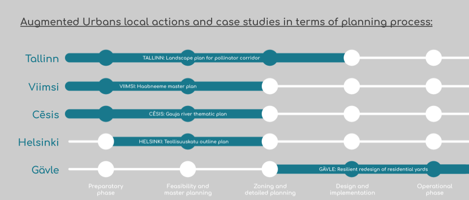
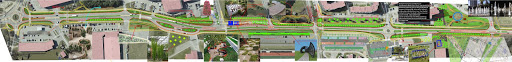
Here, each city’s resulting integrated urban plan is shown in three images. The first visual shows the existing situation, the second one representing public space changes and the third one, where applicable, the volumetric change. The visuals differ in their approach as each Local Action developed their own way of approaching resilience in their own particular case. Hence the variety in representation also shows the diversity in approaches.
Disclaimer: For the purposes of the Augmented Urbans project, the following urban plans are final, but for the municipalities they are a work in progress. The resulting plans are in various stages of analysing, debating and confirming, they are not final implementation or detailed plans of what is to come in these places. Readers wishing to be more informed about a particular urban plan should look up the most up-to-date planning information of that area online. The plans below are illustrative and not legally binding.
Within the framework of the Augmented Urbans project, the aim for Cēsis city was to create a development proposal (a thematic urban plan) for the Gauja adjacent green territories in Cēsis region – Cīrulīši and Gaujaslīči neighborhoods, located in the west side of Cēsis city, some 3 km form the city center. Whilst Gaujaslīči is a less populated area with vast territories of both public and private forests and occasional historic wooden villas or family housing, Cīrulīši used to be a well know resort area during the Soviet era, and is still an active center for winter sports and active nature tourism.
Cēsis Local Action (LA) area is situated in the Gauja national park, which has a variety of protected forest, meadow and aquatic habitats, sandstone walls and elderly tree alleys. Natural values can become a major driver of a site development, yet these are also the most vulnerable areas to be protected. One of the main aims of thematic plan, was to deepen the understanding synergies between sustainable development, resilience, society and the economy in the site.
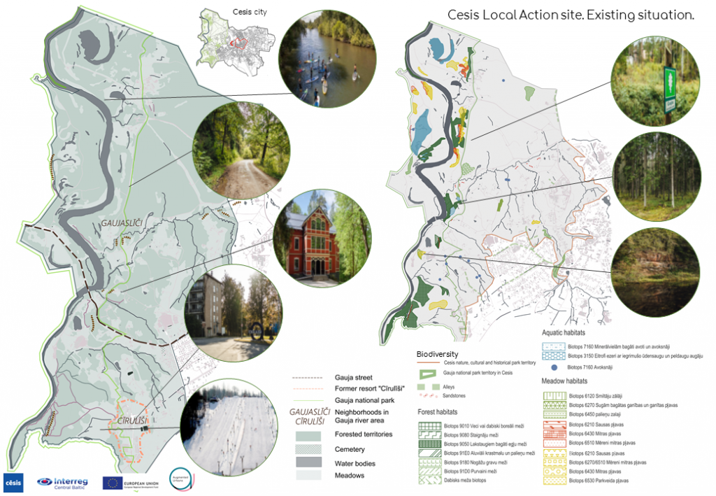
One of the biggest challenges in the area is the lack of infrastructure (accessibility, recreational and service infrastructure). The development of sustainable, resilient and location-specific infrastructure in the area will ensure respect for and appropriate use of ecosystem services. In order to tackle challenges and opportunities presented in the site, an overarching vision was defined for the site: “Gauja adjacent green areas are easily accessible to enjoy a vast spectrum of nature sites, that offer a recreational experience and are protective to the environment”.
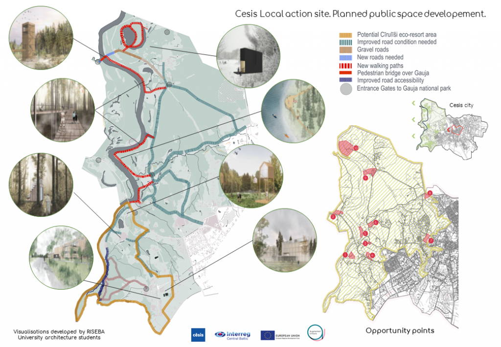
Main solutions depicted above are connected with improving the accessibility of LA area, where it is possible and feasible, including development of new walking paths, a pedestrian bridge over Gauja river on the North of LA site, places where gravel roads must be improved to ensure better accessibility etc. As the LA site is located in the Gauja national park, suggestions for Gauja park entrance gate potential places were made. A future eco-resort area development in Cīrulīši was also proposed, however it might still be a subject to change as Cesis municipality will move forward with resort strategy development in the upcoming years.
Additionally, altogether ten Opportunity points were selected based on data and analyses. These are mainly (but not only) municipality owned sites which show the greatest opportunity for future development of infrastructure objects that could improve the accessibility to Gauja river, provide recreational sites (e.g., point Nb.10 is appropriate for a small size campsite development additional to possible pedestrian bridge across river Gauja). Inspirational visualizations for the LA site were created by students from RISEBA University Architecture faculty and are used as guidelines for site development. All of the proposals include original place-based architectural solutions that use wood and glass materials as reference to the nature sites found in the area – forest and water habitats.
In order to achieve both short- and long-term resilience, Viimsi decided to do a physical intervention in the main road of Viimsi, on Randvere street (between Rohuneeme and Tammepõllu road). This area was identified in the master planning process as an area most likely to benefit from improvements. The area currently has schools, a kindergarten, shops, cafes, services and sports facilities.
The new street plan was developed using the expertise of various professionals, including landscape architects, mobility and environmental experts. The resulting plan is the input for future detailed plans according to the budgetary possibilities of different departments in Viimsi. The concept was developed by SWECO Project AS and is based on the participatory processes undertaken in Viimsi. To improve sustainable mobility, a focus has been placed on walking and cycling. For this purpose, new cycling and walking paths, parking and street lighting has been designed and traffic-calming techniques have been used. To improve sustainability, the landscape solution for the whole area has been updated. To increase biodiversity of areas that currently have cut grass, the new plans include the introduction of new trees and plants that improve the environment for pollinators and other species. To improve the general wellbeing of locals, six new recreation areas have been designed, for more active leisure there is a skating park, fountains and several playgrounds.
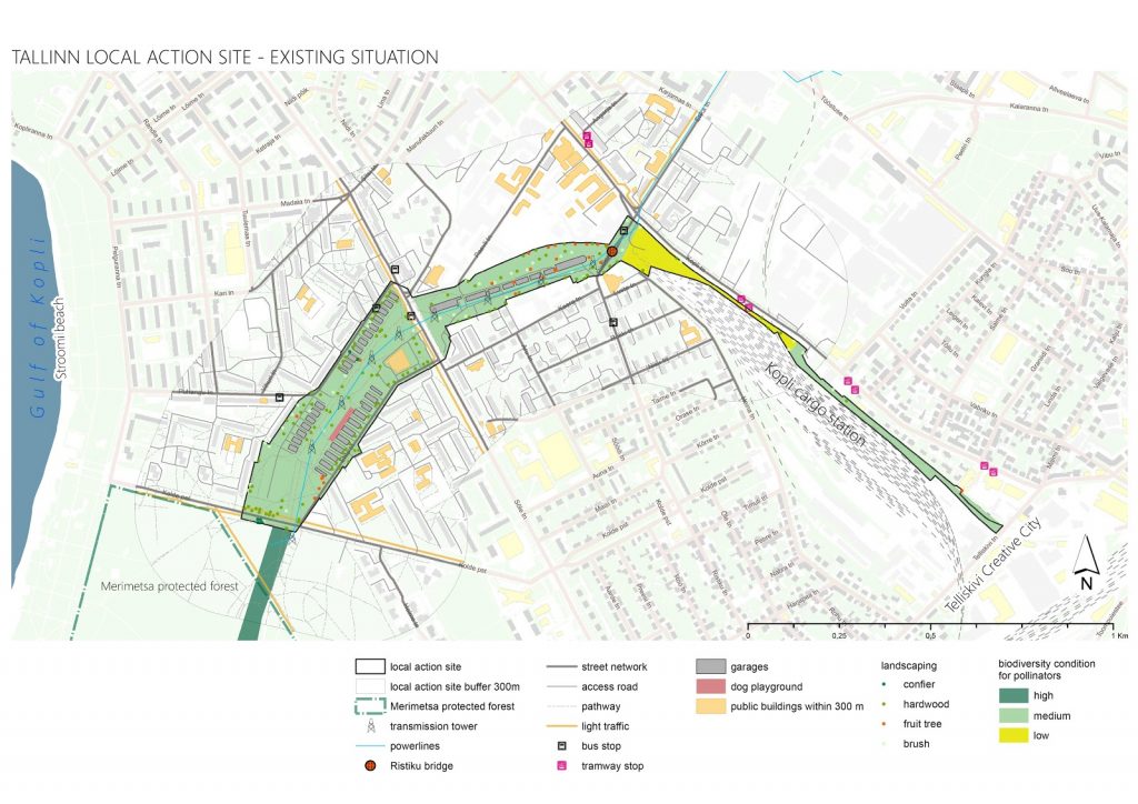
In mapping the existing situation in Tallinn Local Action, an important role was in conducting an inventory of pollinators, the results of which are shown in dark green, light green and yellow on the plan. This served as a conceptual driver for the area planning a Pollinator Highway. The dark green area is situated in Merimetsa protected forest, which is connected to a wide range of habitats for pollinators. By increasing the biodiversity in the area marked with light green, pollinators can also start reaching into the yellow area, which currently is an unused area next to a former cargo train station.
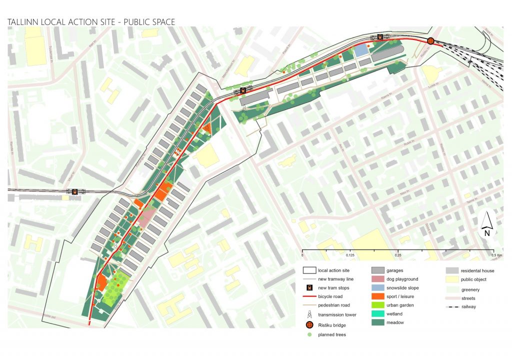
To make the core area more biodiverse, several landscape solutions have been designed. These include having most of the surfaces as meadows, planting more trees and creating wetlands. Considering existing public space and landscape works in Tallinn, several new concepts and methods have been introduced in this project. The area also has a tramway going through it and an urban community garden. To further improve the wellbeing of locals, the area has pockets of activities, including a snowslide slope in winter and other sport and leisure activities.
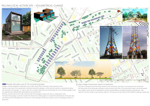
With the main focus on sustainable development and the area situated in the existing built up region of the city, the Tallinn Local Action site does not have plans for new building developments. Instead it is looking to renew the existing garages in the area. The expansion of a garage would not need a detailed plan and would also be more environmentally sound than demolishing and rebuilding. In addition, to preserve the characteristics of the site, the high-voltage transmission towers are kept as landmarks of the area.
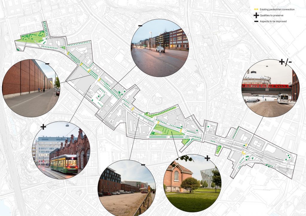
The image shows areas in Teollisuuskatu street areas that can be improved, such as monolithic and inactive ground floor facades, public spaces where pedestrians do not feel safe next to busy roads and unused areas. At the same time there are characteristics worth maintaining, such as the diversity in architectural qualities ranging from industrial to contemporary and the existing green areas. In the Teollisuuskatu area site, specific restrictions are shown in the plans and more general governing principles are presented in writing as a part of the outline plan. The general principles have the same themes that developers have to address when applying for a detailed plan, the idea is to decrease bureaucratic bottlenecks. The general principles include: building rights, cityscape and construction, outdoor areas, noise (pollution, vibration, ground water), the high speed tramline, climate change and traffic with parking. Within these governing principles several tools are used to instigate change towards more resilient urban planning. For example, with the large CO2 footprint of new construction, in order to demolish an existing building a study of the environmental impact of that demolition has to be submitted. The idea is to motivate renovation and retrofitting, before demolishing and constructing a new building.
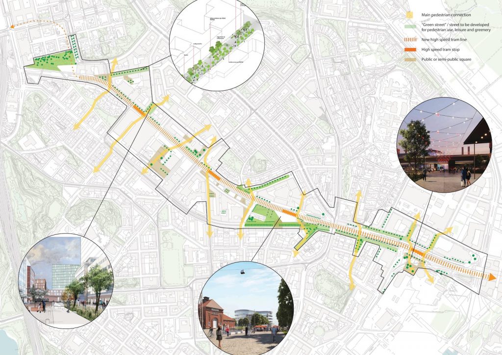
Public space is one of the key drivers of making the area more resilient in four main ways: by having more diverse green areas, enlivening two public squares in order to activate outdoor urban life, planning a high speed tram for sustainable mobility and proposing green streets that are areas of socialisation and biodiversity. The aim of these goals is to increase connectivity both physically (increased pedestrian accessibility) and socially (building resilience through human relations).
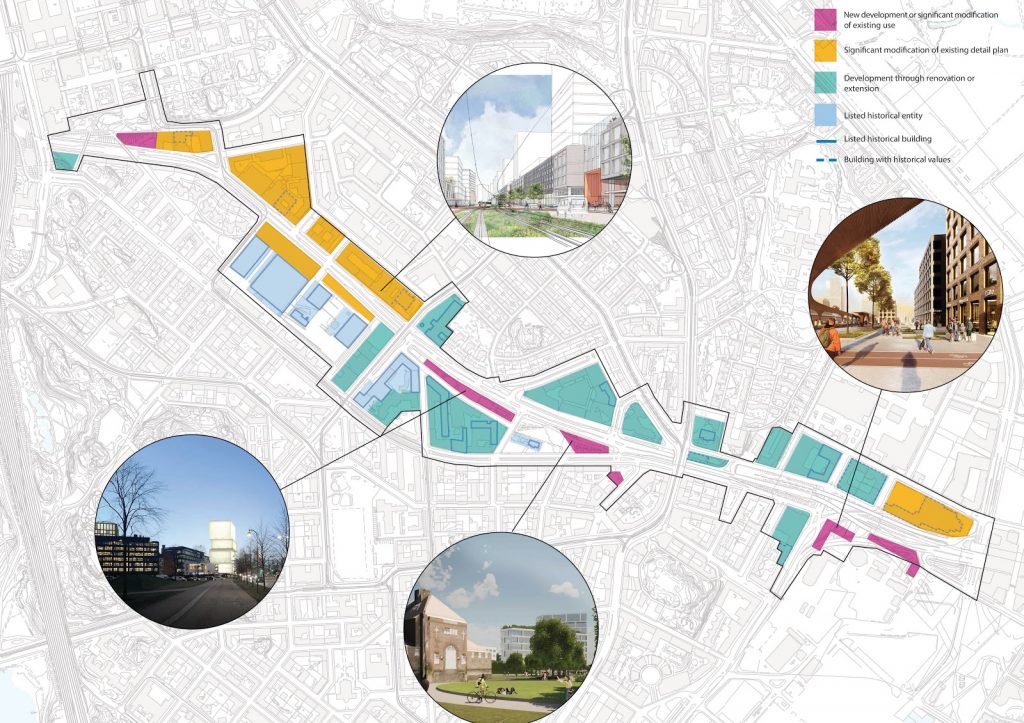
The areas that can be built up or expanded based on the new outline plan are mainly in private ownership. The outline plan describes one holistic view of the whole area which can be executed through gradually changing detailed plans. The plan has both listed buildings and new buildings, but the majority can be developed through renovation, retrofitting or by modifying the existing detail plan. By solving the bigger questions in the outline phase, the detailed plan phase will take less time.
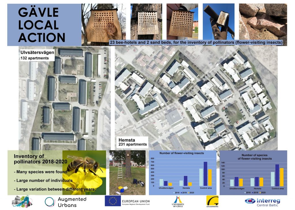
Gävle Local Action site was situated in an already built-up urban location. The housing areas of Hemsta and Ulvsätersvägen were the site for the resilience-improving intervention. To measure the effectiveness, an inventory of pollinators was carried out from 2018 to 2020. The visual shows the satellite view of the housing areas, the results of the pollinator inventory and the methods used in executing the study.
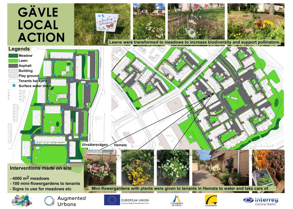
The main public space interventions in Gävle Local Action were to create dry meadows and give mini-gardens to the tenants. The visual shows the location and extent of the created meadows and the three different types of mini-gardens that were handed out. The meadows planted from seeds will take a few years to have their full effect.
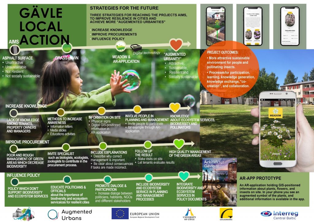
This visual shows key procedural elements of integrating resilience into urban planning processes with a focus of outdoor areas. These processes are increasing knowledge, improving procurement and influencing policy. The image shows the starting point for each of these elements and the end results, as well as the AR application prototype. These results were reached by seeing the implementation of the mini-gardens and meadows, starting from concept to construction and beyond. Such focus on the physical interventions enabled the mapping of various procedural mismatches that sometimes hinder putting resilience into action.