
Less than 100 km from Riga, Cēsis municipality is among the 15 largest urban areas in Latvia with a population of 19,000. Cēsis serves as an educational and cultural centre for the region. Many residents of Cēsis commute to work, for example to Riga. The town has a strong medieval heritage and a vibrant contemporary cultural scene and is aiming to become a more attractive living environment for people of all ages.
For the Local Action, two neighbourhoods and the connection between them were chosen in Cēsis. Both neighbourhoods are located near the Gauja River and are separated with a major street going out of the city and across the river. The first neighbourhood known as Cīrulīši (named after bird skylark) is a populated area – historically the site was a resort, serving the health and wellbeing of people from Latvia and beyond during the Soviet era. The other – Gaujaslīči (named after the meandering Gauja River) – is a more forested area with a few homes on the banks of River Gauja and is environmentally significant in its biodiversity. The focus of the urban plans is to increase the quality of life of the residents, explore the development aspect of the Cīrulīši area, preserve the unique aspects of the sites and create a strong business environment for tourism and active lifestyle operators. The Gauja River area is both in public and private ownership. The Gauja River area is less connected with the town, but it has a ski resort, several hiking trails, a spa hotel, architecture heritage objects and monumental sandstone cliffs. These areas were chosen by their rich and diverse context, and there was a feeling they were not used to their full potential.
During the Augmented Urbans project, the focus for planners was to engage more with locals and the environment. A study was conducted by the Institute for Environmental Solutions Institute to gather high-resolution visual data of the area and, during this process, map the ecological value of the site. This biodiversity data set served as a foundation for the following public participation workshops. One of the main stakeholders of the site operates in the tourism sector, so establishing a clear set of environmental values based on data was crucial in developing the area sustainably.
Several new ways were used to engage locals to participate in different planning processes. In addition to using new technological tools, the participation included organising a Local Planners Forum, testing scenarios with local inhabitants and business owners, taking part in the local annual discussion forum “Lampa: A Conversation Festival”, hiking the planned area and opening a devoted pop-up space / planning office “Mission: Gauja” in the city centre to hold discussions and workshops for gathering ideas for site development. All these approaches served the purpose of reimagining the uses of these areas and involving the end users (including families, children, the elderly, local inhabitants of the site etc.) in the process as much as possible.
A more detailed insight of the resulting planning documents developed in this process can be found in the Integrated Urban Plan section.
Extended reality (XR) solutions
During this project, Cēsis decided to develop one application that was multifunctional but was simple to use and easy to execute. The purpose of the platform was to show ideas in the early stages of planning and let them serve as a basis for participation workshops and idea gathering processes. The interactive application consists of a birds-eye-view of the whole town, 360° views with sketched options of the spatial ideas and a chatbot for feedback and ideas. The application could be used as web-based or be part of a XR participation workshop. The web-based version was useful for general information and wider public engagement. VR glasses were used in group sessions with locals and stakeholders. Using VR glasses allowed participants to have a more vivid experience of the planning department’s ideas and the following discussion was subsequently animated and lively. With a sketched proposal as a starting point of the co-creation, locals were able to generate new ideas and go beyond their initial response. The XR approach also allowed planners to explain specific restrictions and possibilities of the initial ideas. The downside of this approach was its suitability for a more individual co-creation session. With a limited number of VR glasses, the length of time using the glasses was an issue as well as the very immersive nature of the application. Some people who used the glasses did not wish to multitask and discuss at the same time as using the glasses. The approach was more successful in smaller groups.
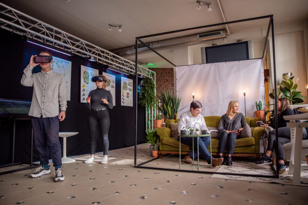
The abundance of XR options can be disorienting for a municipality. In order to arrive at the result described above, extensive consultations were had with an expert (Gunita Kulikovska) to really understand what the planning department needed from the application and in what way it could be used to enhance co-creation. In acknowledging the restraints of the municipality, both in modelling resources and in spatial development, a user-friendly approach for both locals and the municipality officials was arrived at. In addition to the application, a touchscreen was used during pop-ups to further inform locals. The final outcome empowered and inspired the locals to co-create with the planners. The web version of the application can be found HERE.
Key experience – on-site experiences as part of the planning process
While using VR glasses in participation workshops helped to engage immersively with the site, going on-site was also a key experience. In Cēsis’ case and in particular in dealing with the Gauja river area, going on-site took various forms and served as a preparation for both the planners and people participating in the planning process later on. A series of hiking events were organised, during which participants shared personal memories of the green area but also acquired more in-depth knowledge of the site. A part of the hikes was guided by a biologist, explaining the environmental aspects of the unique site and showing particular points of interest and restrictions. This type of a guided tour allowed the planning process to be embedded in more granular knowledge of the area that went beyond the main landmarks and gave an expanded insight into the use of the area by both humans and nature. The on-site hike allowed people to open up emotionally and share vivid memories. The combination of an expert and local experience allowed planners to clarify values for future planning and develop a thinking of the site that acknowledged both passive and active qualities of the area.