
The driving force of the concept was derived from a site survey conducted in summer 2019 that inventoried the pollinators in the core area. The diversity of bees and insects, of which over ten are protected species, inspired the urban planners to focus on pollinators as a central concept in the development of the urban area. In order to preserve the habitat to the species already present, the subsequent landscape architecture solution largely consists of meadows and sustainable mobility options. The whole length of the Pollinator Highway connects various important urban green areas, allowing insects and other animals to move between previously isolated areas. The concept serves the wellbeing of both people and nature.
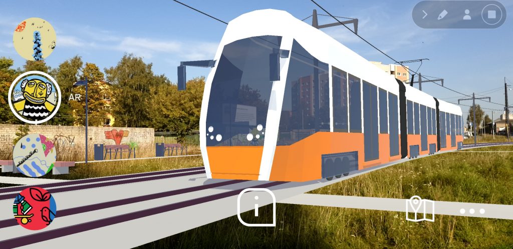
The core area of the Pollinator Highway is a high-voltage power air-cable zone. Historically the area could not be used for health and safety reasons, hence the land is vacant of buildings, and skirted with privately-owned Soviet-time garages. State-owned Elering Co has been investing in changing the air-cables into ground-cables, freeing up the land for new development. As the cables form a network between city districts, it has great potential to be designed as a cross-city network of high-quality urban design and mobility. In the specific area, a new tramline is considered, in addition to a cycling path and a linear park. The landscape architecture solution accommodates various forms of vegetation for pollinators and pockets of activities for people, ranging from football to dining.
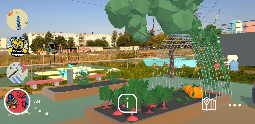
As a first on-site intervention and a way to get people engaging with nature, the planning department in collaboration with Tallinn University sought out gardening enthusiasts, to start a community garden in the area that is also part of the final landscape solution. The plan was to slowly turn the leftover brownfield into a spatially curated environment of biodiverse landscaping. Right after initiating the community garden, the planning department also collaborated with the local district, to develop a new management plan for the area, in order for the grass to be cut less often. The aim was to support biodiversity even before the implementation of a professional landscape plan. A few complaints were received by the local municipality, but the long grass also created an exciting new spatial experience in the area. To further communicate redevelopment plans, a series of murals were painted in the area. To maintain the feel of the area, the existing power towers which act as landmarks will be left intact and repurposed, if possible.
A more detailed insight of the structural plan of the core area of the Pollinator Highway developed in this process can be found in the Integrated Urban Plan section.
Extended reality (XR) solutions
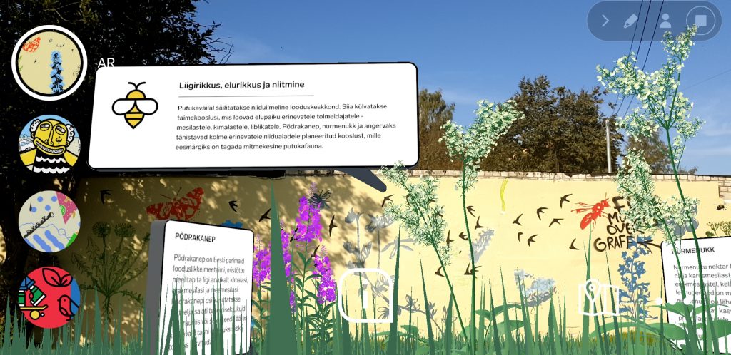
The Tallinn urban planning department already had a platform for gathering ideas, a mobile application called AvaLinn, where plans for developed areas are made accessible to people to comment on. While the initial plan was to make an extension to AvaLinn, they decided to create a related, but independant application with a location-specific augmented reality (AR) function called AvaLinn AR. The idea is that people can walk on site and point their phones on a mural and receive extra information about city plans for the future of the area. So far, the murals communicate about sustainable mobility of a new tramline, increased biodiversity by not mowing the lawns, and bees, leisure activities, and the new retrofitting of Soviet-time garages. Instead of looking at a drawing, people can experience the future changes through the on-site AR application with all their senses. The AR application provides animated 3D visualisations with sound augmented on thesite where the user is at the time. The aim is to make long-term planning visions tangible in the present. Just like other planning departments in the Augmented Urbans project, Tallinn officials found it challenging to get the kind of app they envisioned through outdated procurement processes. In order to improve the quality, they commissioned development ideas for the user interface from Metropolia University of Applied Sciences design students, and also employed an AR specialist to have in-house expertise.
Initially, there was a concern of usability: will the app run smoothly enough in an outdoor environment. There are also other areas of improvement: will people manage to overcome the first-time use barrier of this technology, how well would people perceive the information, would it be a strain on the battery in cold weather.
During the project, Tallinn urban planning department in collaboration with Tallinn University also used other ways to encourage widespread participation. Alongside with person-to-person interviews and discussion at schools, kindergartens, on-site and at the library, Maptionnary and the existing AvaLinn app were used to collect feedback. This mixed approach aimed to ensure that people of all ages and backgrounds were included in the planning process. The AvaLinn AR solution, along with the overall Pollinator Highway activities, were extensively communicated in the local papers and community.
Key experience- -place branding and identity
Place branding is increasingly being used as an urban planning and development tool in advanced economies, as it helps to move from deciding about land use and zoning to a more strategic planning that addresses the symbolic and cultural meaning of a place (Cleave and Arku 2020). Sometimes place branding is used to attract potential buyers or investors, while in urban planning branding it can be used to communicate a bold new vision for an area without using complex drawings or administrative jargon, but visual and linguistic metaphors.
Zenker and Braun (2010) have defined place branding as following:
“A network of associations in the consumers’ mind based on the visual, verbal, and behavioral expression of a place, which is embodied through the aims, communication, values, and the general culture of the place’s stakeholders and the overall place design.”
In Tallinn’s case, place branding as a strategy was adopted early on out of the necessity to communicate with experts from various fields. In discussions they started using the metaphor of Putukaväil, which translates into Pollinator Highway, but locally it has various additional associations. It was partially inspired by New York High Line landscape architecture, but also by the local report on insect biodiversity and learning about the role the area has in the city’s general ecosystem. The brand image helped the planning department to put more resources into designing a pollinator-friendly area in the city and communicating its wider benefits. While the name has been the same from the start, the content has been constantly improved throughout different participatory planning events and idea gatherings. The branding process has served as a way to make a meaningful place in collaboration with various stakeholders and to engage with the site in depth.
In Tallinn’s case, as a part of the branding effort, a full-day pop-up event called Marathon of Nature Observations was organised in collaboration with the Estonian Museum of Natural History. During the event, the Pollinator Highway concept was further communicated using various engaging activities ranging from exhibitions to guided tours identifying the local biodiversity. During this time, the planners were also on-site and engaging with locals.
Photo
References
- Zenker, S., & Braun, E. (2010). Branding a city: A conceptual approach for place branding and place brand management. [Paper presentation]. 39th EMAC Annual Conference 2010, Frederiksberg, Denmark.
- Evan Cleave & Godwin Arku (2020): Place branding and growth machines: Implications for spatial planning and urban development, Journal of Urban Affairs.