
Viimsi is a suburban borough, 9 km northeast of Tallinn, the capital of Estonia. The most densely populated area in Viimsi is Haabneeme with a population of 6,620 as of January 2020. With Viimsi being one of the fastest-growing municipalities in Estonia with a large commuter population, issues of sustainable mobility, environmental resilience and access to public services have arisen. Most of the land is privately owned, the municipality and state own roads and public services. Real estate developers aim to maximise residential areas, while there is a general lack in public services and local jobs. As part of the Augmented Urban project, the Local Action was chosen to address these issues and problems by initiating two processes.
Firstly, since 2019 the comprehensive plan for Haabneeme has been in development. As part of the Augmented Urbans project, the municipality is implementing new virtual communication tools and public participation methods to increase awareness of future developments and increase their planning quality. As with the Randvere road solution, in order to engage with people of different ages and backgrounds, a mixed approach to participation has been used. Part of the process has been presenting the work-in-progress master plan in local discussion forums and to stakeholders using new technologies. For the same purpose, special focus has been placed on the accessibility of online participation tools, so people with no background knowledge could engage with the process easily. The aim is to develop a town that is more congenial for local residents, a place where people like to live, spend their free time or start a business.
Secondly, a new spatial solution was developed for the Randvere road, which is one of the central streets in Viimsi, to achieve a more human-scale and lively urban space with a special focus on resilient landscape solutions. The need for this was identified in the master planning process, where some of the issues needed more direct action than a master plan can facilitate. In the long run, making Randvere road more pedestrian-friendly will activate the centre of the suburb and increase recreation and active mobility opportunities locally. The new street solution has pockets of activities, such as skating and a square for fountains, and the landscape architecture solution facilitates new opportunities in the area. The new vegetation reduces noise and helps to zone pedestrian, cycling and motorised vehicle areas, while creating a habitat for pollinators. In developing this solution, several participation methods were used, ranging from co-creation workshops in the adjacent schools to using 360 views to immersively present the future outcomes of the project to locals.
A more detailed insight of the new main road can be found in the Integrated Urban Plan section.
Extended reality (XR) solutions
During the Augmented Urbans project, Viimsi municipality decided to deploy three digital tools that each address a particular scale of planning and fits the distinct communication needs of the phase. Considering the wide definition of XR, the tools combined digital and XR capabilities in various degrees.
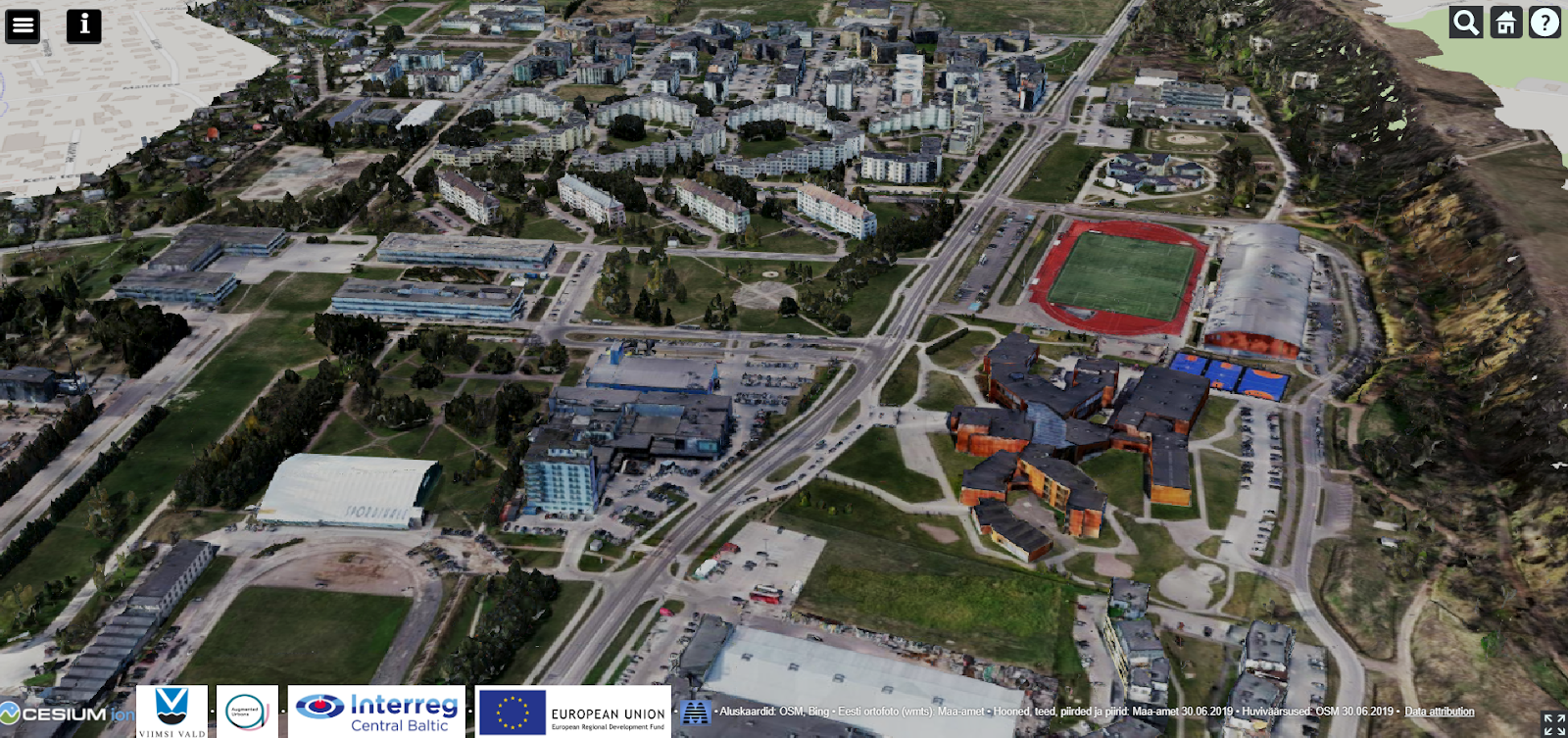
With no previous experience in using XR tools in the municipality, for the first tool Viimsi decided to start with a simple online 3D digital visualisation of the comprehensive plan projected developments and their scope. Initial procurement raised issues for the municipality as the final outcome had all the functions they asked for, but was not as user-friendly as envisioned. In order to develop a better user interface, the municipality collaborated with Metropolia University of Applied Science students, who provided constructive feedback and development ideas to the 3D model user interface, based on using the user journey method for interaction design.
This tool enables the user to digitally explore the 3D model for the ongoing general plan outcomes. They can also give feedback either to specific points or to more general areas. Each user can only see their own comment, while the overview of all comments is visible to the planner in the form of a summary table. The Haabneeme 3D model was a useful tool for the municipality officials and Viimsi residents interested in the planning process.
Based on the public 3D model experience, the local project team decided to further invest in developing an interactive web-based map application to communicate with locals – haabneeme.viimsi.ee. The application gives a clear visual overview of the strategic aims, the guiding principles of spatial development, land use, developing areas, mobility, environmental issues and opportunities and public space developments using visual storytelling, interactive maps and user-friendly data visualisation. It also gives a general outline of the master planning process. This online application was found to be engaging and easily accessible on all screens.
Main page of Viimsi Master Plan
For the third tool, a series of 360° views of the Randvere road solution was assembled to be viewed either online or using VR glasses. This XR visualisation was developed in order to give users a better understanding of the new main street through a pedestrian-eye-level view. As part of the participation process, special effort was put into showing the new main street solution to surrounding schools, both to students and their parents, to gather user experiences and input for the project. The Randvere road project uses solutions that offer more biodiversity and sustainable mobility options, hence there is a need for extra communication about the multifunctionality of these new solutions. For example it needs to be communicated how the specific plants chosen support multi-level biodiversity (plants, pollinators etc.), and also offers other services such as traffic noise minimisation and lowering overall maintenance costs. Similarly, it can be demonstrated how different street design elements help make the area more easily accessible to all modes of transportation.
The other 360° views of the Viimsi Mains Street vision can be seen HERE
Key experience – Planners meeting NIMBY attitudes in suburbans
Historically NIMBY (not in my back yard) movements have been related to societal prejudice and discrimination or to environmental movements (Dear 1992). They range from protesting against planning prisons and drug treatment facilities to boycotting landfills or industrial manufacturing plants/factories near residential areas. With increased urbanisation and the growth of suburbs, planners have started to encounter NIMBYism in residential area developments. What to do?
Often all protests are labelled as NIMBYism, without examining the motivations. In housing developments it can be an anti-growth attitude, single-family housing residents opposing apartment buildings in order to maintain their own privacy or perceived property values (Pendall 1999). It can also be a concern for increased use of public services (transportation, education, greenery). On other end of the spectrum, it can be a quiet discrimination towards new incoming people, for example groups with lower income or different cultural backgrounds. Sometimes also national trends or news can shape local sentiments. Untangling this diverse set of motivations is the first step in addressing NIMBYism. In Viimsi a local participation planning event was used to hear out locals and identify their expectations for new developments.
By and large the solutions to such resistance towards housing falls into two categories. Either a solution is negotiated with the local community, be it an investment in services or rescaling of the development, or it is a “Decide-Announce-Defend” approach that can involve courts (Massa 2019). While planners can accommodate some of the local community needs and wishes in the planning process, the ultimate solution is often dependent on the political actors.
References
- Michael DEAR (1992). Understanding and Overcoming the NIMBY Syndrome, Journal of the American Planning Association, 58:3, 288-300.
- Agostino MASSA (2019). Coping with the “NIMBY syndrome”: political issues related to the building of big infrastructures in liberal democracy countries.
- Rolf PENDALL (1999). Opposition to Housing NIMBY and Beyond.